Contents
| A.2 Free & client serverside | Contents |
![]() As of: May 15, 2007
As of: May 15, 2007
|
1. General | |
| Name | CartoWeb |
| URL | |
| Home | http://cartoweb.org |
| Documentation | http://cartoweb.org/documentation.html |
| Download | http://cartoweb.org/downloads.html |
| Live Demo | http://cartoweb.org/demo.html |
| Current version | 3.3.0 |
| Last update | August 31, 2006 |
| License | GNU GPL |
| Developed by | Camptocamp SA, Switzerland |
| Short Description | CartoWeb is a comprehensive web mapping application for creating specialized or more extensive applications. Use as SOAP Web Service is also possible. |
| 2. System | |
| Architecture | client-serverside |
| Programming language | PHP 5 |
| Prerequisites | • Webserver (recommended: Apache) • PHP 5.0.3+ • UMN MapServer 4.4+ and PHP/MapScript • PostgreSQL/PostGIS (optional) |
| Supported browser | compatible with: Mozilla 1.7+, Firefox 1.07+, IE
6+, Safari 1.3.2+ incompatible with Opera, IE 5 (Mac), Konqueror |
| Where applicable, integration with other software | based on UMN MapServer |
| 3. Community | |
| Revision Administration | CVS (cvs -d :pserver:anonymous@dev.camptocamp.com:/var/lib/cvs/ public co cartoweb3) |
| Mailing Lists (URL) | http://cartoweb.org/contact.html |
| Developer ML | |
| Mails per month1 | 16 |
| Total number of active developers2 | 12 |
| User ML | |
| Mails per months1 | 80 |
| Total users per month2 | 86 |
| Commercial support | k. A. |
| 4. Documentation | |
| For installation/development/operation (suggestions, tutorials, URL) | very good and comprehensive (250 pages), user manual und developer manual (incl. installation instructions); Workshop: GettingStarted + Materials |
| 5. Usability | |
| All analysis is based on demo: http://cartoweb.org/demos/demoCS.php | |
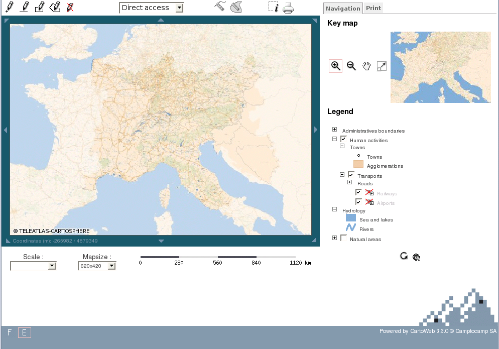
| Usability - General Impression | seems quite static, conspicuous updating of map, overview map and legend after each change; 'Loading' message requires a lot of patience |
|
Main map | adjustable map size (via Combobox), current coordinates of control panel on map edge |
| Overview map | fixed zoom level, hence no centering required; sections can only be moved by clicking |
| Layer overview | combined with a legend; can be de/activated with check boxes; thematically grouped and collapsible; a lot of information: risk of interleaving; update button needs to be pressed after change has been made |
| Legend | combined with layer display; collapsible, disadvantage: appears very interleaved, cumbersome to open all legend components with corresponding loss of orientation, in part not always clear what is layer and what is legend only |
| Scale bar | bar below map, additional scale menu field |
| Toolbar | usual functions, noticeable: drawing tools |
| Zoom bar | - |
| Pan navigation panel | on map edge |
| General zooming | max/min zoom level can only be seen on scale Combobox bar, zoom magnifier remains active |
| Zooming with double-click | - |
| Zooming with mousewheel | - |
| Zooming with zoom box | yes (also possible by holding down Shift-key; colorful underlay of pulled-out area) |
| General panning | unhindered smooth panning with Drag&Drop; also gradually by using navigation arrows |
| Zooming/panning with keyboard | - |
| Tiling | - |
| 6. Other Features | |
| All analysis is based on demo: http://cartoweb.org/demos/demoCS.php | |
| Analysis function | distance, area and drawing functions, queries |
| Search function | - |
| Help function | - |
| Print function | very good: implemented as pdf export, with formatting settings, title, description, legend position and reference map |
| 7. Notes | |
| - | |
| 8. Screenshot | |
| of analyzed demo | |
| |
![]() As of: May 15, 2007
As of: May 15, 2007
|
1. General | |
| Name | Chameleon |
| URL | |
| Home | http://chameleon.maptools.org |
| Documentation | http://chameleon.maptools.org/index.phtml?page=docs.html |
| Download | http://chameleon.maptools.org/index.phtml?page=downloads.html |
| Live Demo | http://www.mapsherpa.com/hawaii |
| Current version | 2.4.1 |
| Last update | September 6, 2006 |
| License | X11-Style |
| Developed by | DM Solutions Group, Canada |
| Short Description | Chameleon is a shared, comprehensivly configurable PHP environment for the development of web mapping applications. It is based on the OGC standards for web mapping services (WMS) and WMT Viewer Contexts. Chameleon allows for a quick generation of new applications by way of prepared widgets.The system can be expanded by several widgets. |
| 2. System | |
| Architecture | client-serverside |
| Programming language | PHP |
| Prerequisites | • PHP 4.3.x+ • UMN MapServer 4.0+ and PHP/MapScript |
| Supported browser | k. A. |
| Where applicable, integration with other software | basiert auf UMN MapServer |
| 3. Community | |
| Revision Administration | CVS (http://chameleon.maptools.org/index.phtml?page=cvs.html) |
| Mailing lists (URL) | only one ML for users and developers: http://chameleon.maptools.org/index.phtml?page=mailinglist.html |
| Developer ML | |
| Mails per month1 | - |
| Total number of active developers2 | - |
| User ML | |
| Mails per month1 | 51 |
| Total number of active users2 | 63 |
| Commercial support | DM Solutions Group, Canada |
| 4. Documentation | |
| For installation/development/operation (suggestions, tutorials, URL) | DeveloperGuide, InstallationsGuide, JavaScriptAPI, Widgets Documentation - very comprehensive, with examples |
| 5. Usability | |
| All analysis is based on demo http://www.mapsherpa.com/hawaii | |
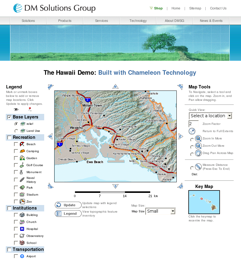
| Usability - General Impression | mouse cursor does not reflect selected functions - irritating; no feedback on load time status during updating; limit-less zoom depth is irritating; pre-defined map areas can be selected; easy-to-see layer display, manual updating only |
|
Main map | map size can be set via menu field, pre-defined map sections |
| Overview map | fixed zoom level, hence centering is not possible; section can be moved only by click |
| Layer overview | can be de/activated with check boxes; thematically grouped; after change has been made, need to press update button; not collapsible: very long list requires a lot of scrolling |
| Legend | opens in pop-up window, static map elements only; dynamic map elements are shown on layer list |
| Scale bar | Bar is located below the map |
| Toolbar | well-defined, partly divided with hyphens, adjoining explanations are redundant; buttons: zoomIn/Out, Pan, Reset, Distance function, Update, Legend, QuickView; noticeable: zoom factor |
| Zoom Bar | - |
| Pan Bar | at map edge |
| General zooming | limitless max/min zoom levels; missing zoom depth orientation; adjustable zoom factor |
| Zooming with double-click | - |
| Zooming with mousewheel | - |
| Zooming with zoom box | yes (with zoom-in tool) |
| General panning | unhindered smooth panning with Drag&Drop; also gradually via navigation arrows |
| Zooming/panning with keyboard | - |
| Tiling | - |
| 6. Other Features | |
| All analysis is based on demo http://www.mapsherpa.com/hawaii | |
| Analysis function | Distance function |
| Search function | - |
| Help function | - |
| Print function | very good: implemented as pdf export, with formatting settings, title, description, legend position and reference map |
| 7. Notes | |
| numerous PlugIns (Widgets) available; easy to program own widgets | |
| 8. Screenshot | |
| of analyzed demo | |
| |
![]() As of: May 15, 2007
As of: May 15, 2007
|
1. General | |
| Name | deegree iGeoPortal |
| URL | |
| Home | http://deegree.org |
| Documentation | http://deegree.org/downloads/releases/igeoportal_std/deegree-igeoportal-std_v2pre1_doc.pdf |
| Download | http://deegree.org/deegree/portal/media-type/html/user/anon/page/default.psml/js_pane/download |
| Live Demo | http://geoportal.wuppertal.de |
| Current version | 1.2.1 (stable) |
| Last update | September 15, 2005 |
| License | GNU LGPL (amended, 2007-11-15) |
| Developed by | lat/lon, Bonn |
| Short Description | iGeoPortal is a browser-based client that builds on WMS, WFS and Proxy Service services; it is primarily used for driving the WMS. iGeoPortal is the client portal component from the degree project. |
| 2. System | |
| Architecture | client-serverside |
| Programming language | PHP |
| Prerequisites | • Java 1.5.x • Tomcat 5.5.x |
| Supported browser | Mozilla/Firefox; IE |
| Where applicable, integration with other software | - |
| 3. Community | |
| Revision Administration | SVN (http://wald.intevation.org/projects/deegree/) |
| Mailing Lists (URL) | iGeoPortal community does not exist -
only general degree user and developer ML: https://lists.sourceforge.net/lists/listinfo/deegree-users https://lists.sourceforge.net/lists/listinfo/deegree-devel |
| Developer ML | |
| Mails per month1 | 49 |
| Total number of active users2 | 202 |
| User ML | |
| Mails per month1 | 92 |
| Total number of active users2 | 106 |
| Commercial support | lat/lon, Bonn |
| 4. Documentation | |
| for installation/development/operation (suggestions, tutorials, URL) | as well as new (v2) and old documentation available in pdf; brief installation instructions only; comprehensive configuration section, URLnur kurze Installationsanleitung; umfangreicher Konfigurationsteil, URL see above |
| 5. Usability | |
| All analysis is based on demo http://geoportal.wuppertal.de | |
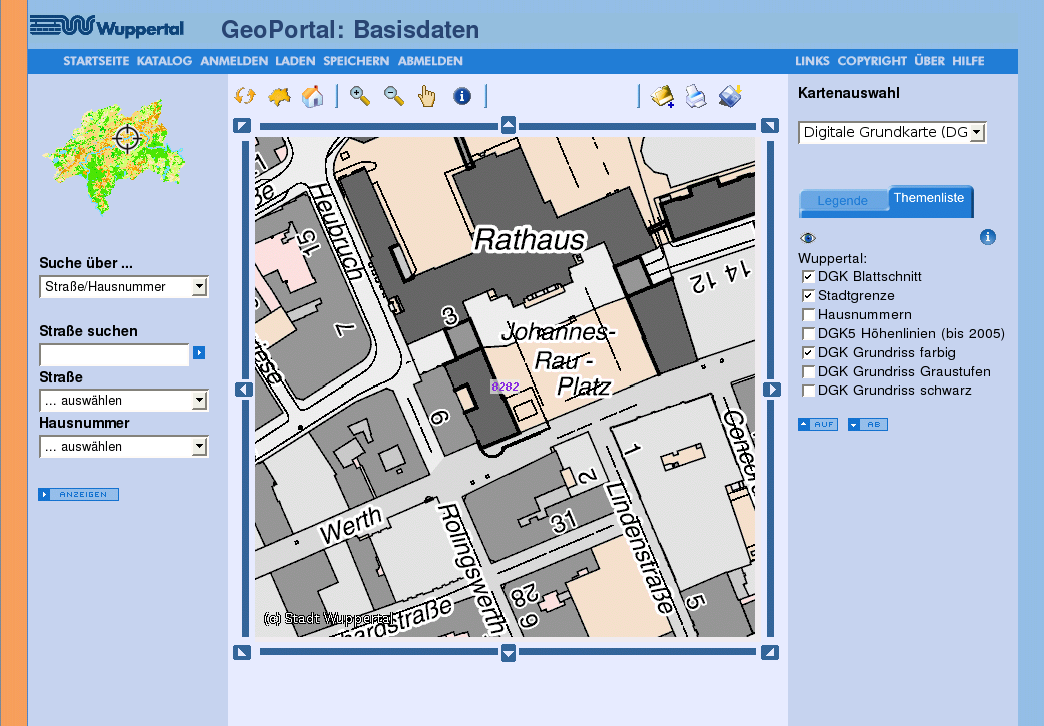
| Usability - General Impression | on the whole easy-to-understand and well-arranged, relatively long map load time, message Map is updating requires patience, especially during panning (inacceptable); unlimited zoom depth is irritating. |
|
Main map | many map themes can be selected |
| Overview map | fixed zoom level, hence no centering required; section can only be moved by clicking; does not adjust to style of main map |
| Layer overview | thematically grouped (with the help of tabs and Combobox; after making changes a manual updating of map is required; layer sequence can be changed, possible to select a layer |
| Legend | comprehensive; depends on chosen map and theme list; legend, layer and maps should be displayed together |
| Scale bar | - |
| Toolbar | clear, divided by hyphens; update buttons cumbersome; convenient way of adding new WMS services, data download for registered usersr |
| Zoom bar | - |
| Pan navigation panel | on map edge |
| General zooming | unlimited zoom-in, missing zoom depth orientation |
| Zooming with double-click | - |
| Zooming with mousewheel | - |
| Zooming with zoom box | yes (with zoom-In tool) |
| General panning | unhindered smooth panning with Drag&Drop; also gradually using navigation arrows |
| Zooming/panning with keyboard | - |
| Tiling | - |
| 6. Other Features | |
| All analysis is based on demo http://geoportal.wuppertal.de | |
| Analysis function | queries (have to choose from theme list) |
| Search function | city district/accomodation searches: 2 Comboboxes, must confirm;street search: at least three characters, confirm entry, street/house numbers meeting this criteria are shown in combobox, final selection must be confirmed with extra button - not very user friendly! |
| Help function | comprehensive user help topics can be retrieved from new browser window |
| Print function | for printing current map section with accompanying legend is opened in browser window |
| 7. Notes | |
| iGeoPortal can be expanded as needed; at this time following module is available: map (supports WMS, WMC and own maps), download (data as GML or Shapefile), gazetteer (supports spatial research), security (integration of deegree iGeoSecurity is possible), catalogue (access to meta dates through Catalogue Service) | |
| 8. Screenshot | |
| of analyzed demo | |
| |
![]() As of: May 15, 2007
As of: May 15, 2007
|
1. General | |
| Name | ka-Map |
| URL | |
| Home | http://ka-map.maptools.org |
| Documentation | http://ka-map.ominiverdi.org/wiki/index.php/Main_Page |
| Download | http://ka-map.maptools.org/index.phtml?page=downloads.html |
| Live Demo | http://ka-map.ominiverdi.org/wiki/index.php/Links_to_some_ka-Map_applications |
| Current version | 1.0 |
| Last Update | February 5, 2007 |
| License | MIT |
| Developed by | DM Solutions Group, Canada |
| Short Description | Ka-Map intends to provide a JavaScript API for the development of highly interactive web mapping interfaces. |
| 2. System | |
| Architecture | client-serverside |
| Programming language | JavaScript, PHP |
| Prerequisites | UMN MapServer und PHP/MapScript |
| Supported browser | Mozilla/Firefox 1.0+; IE 6; Safari; Opera 7+; Netscape 7+; Epiphany |
| Where applicable, integration with other software | based on UMN MapServer |
| 3. Community | |
| Revision Administration | CVS (http://ka-map.maptools.org/index.phtml?page=cvs.html) |
| Mailing Lists (URL) | http://ka-map.maptools.org/index.phtml?page=mailinglist.html |
| Developer ML | |
| Mails per month1 | 11 |
| Total number of active developers2 | 7 |
| User ML | |
| Mails per month1 | 96 |
| Total number of active users2 | 121 |
| Commercial support | DM Solutions Group, Canada |
| 4. Documentation | |
| for installation/development/operation (Suggestions, tutorials, URL) | comprehensive (good start with map server settings etc., Overlay API, User guide (!) and developer documentation); installation instruction in the readme.txt in installation folder |
| 5. Usability | |
| All analysis is based on the current CVS(!) demo: http://www.ominiverdi.org/ka-map/ka-map/htdocs/ | |
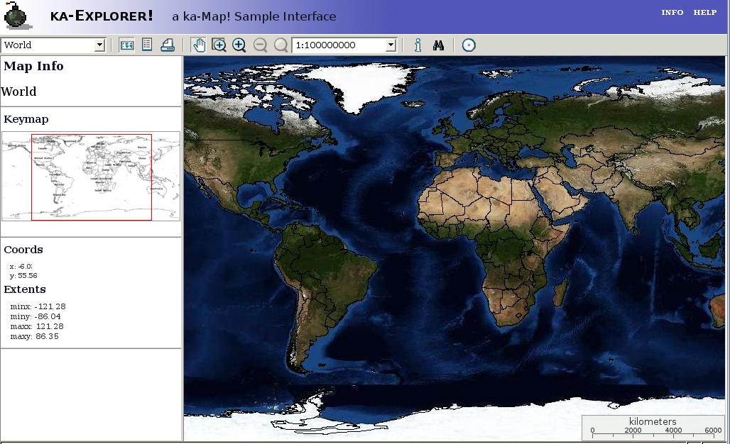
| Usability - General Impression | comprehensive toolbar; GUI well laid out; comfortable panning; missing zoom depth orientation |
|
Main Map | map size dynamically adjusts to size of browser window |
| Overview map | fixed zoom level, hence centering is not possible; section can be moved with Drag&Drop, main map is updated after release |
| Layer overview | combined with legend; can be deactivated with check boxes; adjustable layer sequence and transparency; thematically grouped and collapsible; a lot of information: interleaving danger |
| Legend | combined with layer display, pulled up by a tab |
| Scale bar | bar is semi-transparent and integrated into map; additionally - scale menu field |
| Toolbar | comprehensive; usual functions, noticeable: send-this-view-to-a-friend button |
| Zoom bar | - |
| Pan navigation panel | - |
| General Zooming | appropriate zoom buttons are deactivated at max-/min levels; total of 5 zooming tools (zoomIn, zoomBox, zoomOut, zoomReset, Scale menu field); |
| Zooming with double-click | - |
| Zooming with mousewheel | yes |
| Zooming with zoom box | yes (with extra zoom tool; colored underlay of pulled-out area) |
| General panning | unhindered, smooth panning with Drag&Drop; no navigation arrows; sometimes iritating delays during reloading of tiles |
| Zooming/panning with keyboard | - |
| Tiling | ja |
| 6. Other Features | |
| All analysis is based on the current CVS(!) demo: http://www.ominiverdi.org/ka-map/ka-map/htdocs/ | |
| Analysis function and Queries | |
| Search function and country search | |
| Help function | short, semi-transparent instructions with icons and explanation on top of the map, well implemented |
| Print function | can be saved in various formats: pdf, png, jpg, gif, geotiff; with legend and scale |
| 7. Notes | |
| AJAX u. MapServer settings for ka-Map: http://www.xml.com/lpt/a/1606 | |
| 8. Screenshot | |
| of analyzed demo | |
| |
![]() As of: May 15, 2007
As of: May 15, 2007
|
1. General | |
| Name | Mapbender |
| URL | |
| Home | http://www.mapbender.org |
| Documentation | see Home |
| Download | http://www.mapbender.org/index.php/Download_Mapbender |
| Live Demo | http://www.mapbender.org/index.php/Mapbender_Gallery |
| Current version | 2.4.1 |
| Last update | March 23, 2007 |
| License | GNU GPL |
| Developed by | WhereGroup, Bonn |
| Short Description | Mapbender is a web-based GIS frontend implemented as PHP-based environment for the OGC-WMS/WFS conforming management of display, maintenance, navigation and queries. |
| 2. System | |
| Architecture | client-serverside |
| Programming language | PHP |
| Prerequisites | • Webserver (Apache, MS IIS) • PHP • database (MySQL or PostgreSQL) |
| Supported browser | Mozilla/Firefox 1.x+, IE 6+ |
| Where applicable, integration with other software | - |
| 3. Community | |
| Revision Administration | SVN (http://www.mapbender.org/index.php/SVN) |
| Mailing Lists (URL) | http://www.mapbender.org/index.php/Mapbender_Mailing_Lists |
| Developers ML | |
| Mails per month1 | 55 |
| Total number of active developers2 | 46 |
| User ML | |
| Mails per month1 | 107 |
| Total number of active users2 | 98 |
| Commercial support | WhereGroup, Bonn |
| 4. Documentation | |
| for installation/development/operation (suggestions, tutorials, URL) | very good installation manual (http://www.mapbender.org/index.php/Installation_de, german); general info for users; available in Englisch, German) |
| 5. Usability | |
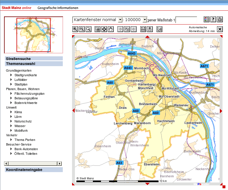
| All analysis is based on demo http://www.mainz.de/mainzextern/geografischeinformationen/index.htm | |
| Usability - General impression | quick load time even without AJAX; many functions; missing zoom depth orientation; layer overview minimizable - easy-to-see |
|
Main map | any map size can be set via Drag&Drop |
| Overview map | unchanging zoom level, as a result no centering required; section can only be moved by click, pull out of new area possible |
| Layer overview | thematically grouped and completely minimizable; layers are collapsible and can be de/activated with through check boxes |
| Legend | legend button opens another window containing a lot of additional information; disadvantage: cumbersome and convoluted |
| Scale bar | Bar is integrated into map (no transparency); additional scale menu field and editable scale text field exist |
| Toolbar | very extensive; noticeable: determine new centre of picture, show coordinates (activate with click under the map), sign off (automatically after 15 minutes), street search, enter coordinates |
| Zoom bar | - |
| Pan navigation panel | on map edge |
| General zooming | Zoom-In/Out tools remain visually active at max/min level (function is deactivated); Zoom Reset; Zoom History (previous, next) |
| Zooming with double-click | - |
| Zooming with mousewheel | - |
| Zooming with zoom box | yes (with extra zoom box tool) |
| General panning | unhindered smooth panning via Drag&Drop; also gradually using navigation arrows |
| Zooming/panning with Keyboard | - |
| Tiling | - |
| 6. Other Features | |
| All analysis is based on demo http://www.mainz.de/mainzextern/geografischeinformationen/index.htm | |
| Analysis function | Queries, measurement function, coordinates pad |
| Search function | Street search |
| Help function | Operating suggestions page, tool tips |
| Printing function | generates HTML; with title, date, scale, description |
| 7. Notes | |
| • Geo CMS • Security Management • quick map assembly through PNG-Interlacing | |
| 8. Screenshot | |
| of analyzed demo | |
| |
![]() As of: May 15, 2007
As of: May 15, 2007
|
1. General | |
| Name | Mapbuilder |
| URL | |
| Home | http://communitymapbuilder.org |
| Documentation | http://communitymapbuilder.org/display/MAP/User+Guide |
| Download | http://communitymapbuilder.org/display/MAP/Downloads |
| Live Demo | http://communitymapbuilder.org/display/MAP/Examples |
| Current version | 1.0.1 |
| Last update | July 19, 2006 |
| License | GNU LGPL |
| Developed by | OSGeo |
| Short Description | Mapbuilder is an AJAX, web-based map client for the WMS and transactional WFS (WFS-T) OGC services. The modular design permits the installation of own widgets. |
| 2. System | |
| Architecture | client-serverside |
| Programming language | JavaScript, XML |
| Prerequisites | Apache/PHP oder Tomcat |
| Supported browser | Firefox 1.0+, Internet Explorer 6.0+, Mozilla
1.3+, Navigator 6+ Incompatible with: IE 5.5, Safari, Netscape 4 |
| Where applicable, integration with other software | - |
| 3. Community | |
| Revision Adminstration | SVN (http://communitymapbuilder.org/display/MAP/SVN+Repository) |
| Mailing Lists (URL) | http://ka-map.maptools.org/index.phtml?page=mailinglist.html |
| Developer ML | |
| Mails per month1 | 120 |
| Total number of active developers2 | 47 |
| Anwender-ML | |
| Mails per month1 | 65 |
| Total number of active users2 | 78 |
| Commercial support | Contact through developer ML |
| 4. Documentation | |
| for installation/development/operation (suggestions, tutorials, URL) | well structured user guide, succinctly written; installation: http://communitymapbuilder.org/display/MAP/Installing+MapBuilder; tutorials and QuickStart see link under (1) |
| 5. Usability | |
| All analysis is based on demo http://geoservices.cgdi.ca/mapbuilder/demo/Demis/index.html | |
| Usability - General Impression | well laid out and self-explanatory; noticeable feature: 'Back' and 'Forward' buttons; no feedback on load time status during updating, max/min zoom depth not defined (at sufficiently wide zoom both result in error messages) |
|
Main map | active panel position in degrees, minutes and seconds at map edge |
| Overview map | - |
| Layer overview | can be de/activated with check boxes (see Time Series Demo http://geoservices.cgdi.ca/mapbuilder/demo/timeSeries/index.html) |
| Legend | - |
| Scale bar | only editable scale text field is available |
| Toolbar | usual functions, noticeable(1): Zoom History (stores recently retrieved map sections); noticeable(2): area of interest funktion (exact function unclear - could not be tested in demo) |
| Zoom bar | - |
| Pan navigation panel | - |
| General zooming | maximum zoom level only recognizeable in scale text field (Value '0'), WMS error message with additional zoom-in; minimum zoom level not defined, map disappears with sufficiently high zoom-out, followed by WMS error message - Zoom magnifier still active |
| Zooming with double-click | - |
| Zooming with mousewheel | - |
| Zooming with zoom box | yes (also possible by pressing Shift-key; colored underlay of pulled-out area) |
| General panning | unhindered, smooth panning per Drag&Drop; no navigation arrows |
| Zooming/panning with keyboard | - |
| Tiling | - |
| 6. Other Features | |
| All analysis is based on demo http://geoservices.cgdi.ca/mapbuilder/demo/Demis/index.html | |
| Analysis function | 'area of interest' funktion (see toolbar) |
| Search function | - |
| Help function | - |
| Print function | - |
| 7. Notes | |
| • uses AJAX • ModelViewController design pattern • Draws maps of WMS, WFS, GeoRSS und Google Maps • supports Web Map Context (WMC) and Open Web Services Context • SVG/VML rendering as of version 1.5 | |
| 8. Screenshot | |
| of analyzed demo | |
| |
As of: May 15, 2007
|
1. General | |
| Name | MapGuide Open Source |
| URL | |
| Home | https://mapguide.osgeo.org |
| Documentation | https://mapguide.osgeo.org/documentation.html |
| Download | https://mapguide.osgeo.org/downloads.html |
| Live Demo | https://mapguide.osgeo.org/livegallery.html |
| Current Version | 1.1.0 |
| Last update | 2006-12-09 |
| License | GNU LGPL |
| Developed by | Autodesk, USA; now: OSGeo |
| Short Description | MapGuide Open Source is a web mapping platform for the development and use of spatially-referenced application. |
| 2. System | |
| Architecture | client-serverside |
| Programming language | PHP, for application development .NET oder Java are also possible |
| Prereqisites | • MapGuide Server (Linux or Windows) • Webserver (Apache or MS IIS) • Application Development (PHP 5.0.5+; .NET Framework 2.0 (optional); Java JDK 5.0 and Tomcat Servlet engine version 5.5.12 (optional) • PROJ.4 |
| Supported Browser | Mozilla Firefox, IE, Safari |
| Where applicable, integration with other software | - |
| 3. Community | |
| Revision Administration | SVN (https://mapguide.osgeo.org/subversionconfig.html) |
| Mailing Lists (URL) | dev
(http://lists.osgeo.org/mailman/listinfo/mapguide-internals) user (http://lists.osgeo.org/mailman/listinfo/mapguide-users) |
| Developer ML | |
| Mails per month1 | 168 |
| Total number of active developers2 | 42 |
| User ML | |
| Mails per month1 | 527 |
| Total number of active users2 | 297 |
| Commercial support | Autodesk, USA |
| 4. Documentation | |
| For installation/development/operation (suggestions, tutorials, URL) | extensive documentation and installation manual, GettingStarted manual very good; URL at (1) |
| 5. Usability | |
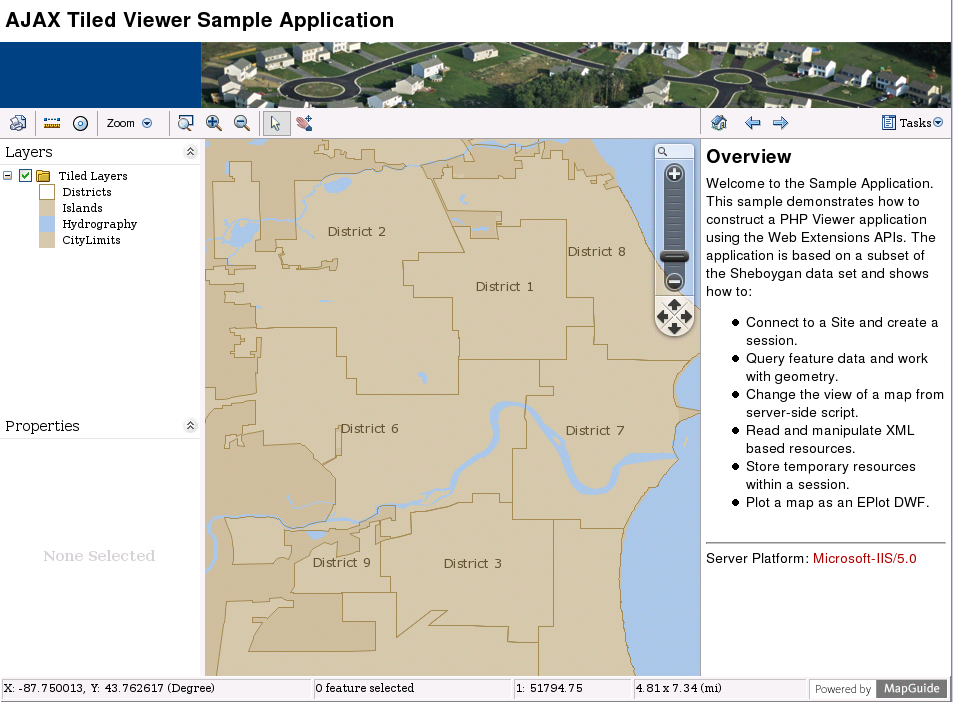
| All analysis is based on demo http://data.mapguide.com/mapguide/phpviewersample/ajaxtiledviewersample.php | |
| Usability - General impression | dynamic zoom bar; well-arranged layout; status bar with coordinates and scale; mouse cursor does not reflect selected functions - irritating |
|
Main map | map size adjusted dynamically to browser window |
| Overview map | - |
| Layer Overview | combined with legend; can be de/activated through check boxes; thematically divided and collapsible |
| Legend | - |
| Scale bar | only scale value shown in status bar |
| Toolbar | commonly-used functions (ZoomIn/Out, Zoom box, Pan, Queries, Delete and Print function); noticeable: Zoom menu with history buttons (previous, next) and Reset, as well as extensive Buffer function |
| Zoom bar | ability to freely place on map(!), together with pan navigation |
| Pan navigation panel | integrated below zoom bar |
| General zooming | good zoom depth orientation with zoom bar; no deactivation of zoom buttons at maximum zoom level |
| Zooming with double-click | - |
| Zooming with mouse wheel | - |
| Zooming per zoom box | yes (with extra zoom box tool; also possible with held-down Shift-key; color shading of selected area) |
| General panning | unhindered smooth panning with Drag&Drop; in addition gradually via navigation arrows of zoom bar |
| Zooming/panning with keyboard | - |
| Tiling | ja |
| 6. Other Features | |
| All analysis is based on demo http://data.mapguide.com/mapguide/phpviewersample/ajaxtiledviewersample.php | |
| Analysis function | queries, Delete function, Are function |
| Search function | Address and Owner |
| Help function | - |
| Print function | optional addition of legends, titles, north arrow; opens as HTML in pop-up; good implementation |
| 7. Notes | |
| • uses own XML data base structure • 2 viewers: AJAX and DWF (vector-based, only for Win, PlugIn required) • commercial-proprietary version: Autodesk MapGuide Enterprise 2007 • fitting Authoring Tool MapGuide Studio in MapGuide Web Server Extensions • put under GNU LGPL by Autodesk in November 2005 • http://www.heise.de/newsticker/meldung/66808 | |
| 8. Screenshot | |
| of analyzed demo | |
| |
![]() As of: May 15, 2007
As of: May 15, 2007
|
1. General | |
| Name | MappingWidgets |
| URL | |
| Home | http://mappingwidgets.sourceforge.net |
| Documentation | http://mappingwidgets.sourceforge.net/manual |
| Download | http://sourceforge.net/project/showfiles.php?group_id=130528 |
| Live-Demo | http://mappingwidgets.sourceforge.net/demo/mapserver |
| Current version | 0.3.1 |
| Last update | March 17, 2006 |
| License | GNU GPL |
| Developed by | k. A. |
| Short Description | A map widget (Zoom, Pan, Information etc.) for simple OGC WMS clients. PHP Smarty expanded with corresponding plugins. |
| 2. System | |
| Architecture | client-serverside |
| Programming language | PHP, JavaScript |
| Prerequisites | • Smarty (PHP template framework) • UMN Mapserver and PHP/MapScript (optional) |
| Supported browser | k. A. |
| Where applicable, integration with other software | based on UMN MapServer (optional) |
| 3. Community | |
| Revision Administration | SVN (http://sourceforge.net/svn/?group_id=130528) |
| Mailing Lists (URL) | - |
| Developer ML | |
| Mails per month1 | - |
| Total number of active developers2 | - |
| User ML | |
| Mails per month1 | - |
| Total number of active userss2 | - |
| Commercial support | k. A. |
| 4. Documentation | |
| For installation/development/operation (suggestions, tutorials, URL) | Installation, Usage, Design - very short and brief, missing examples, not very helpful; URL under (1) |
| 5. Usability | |
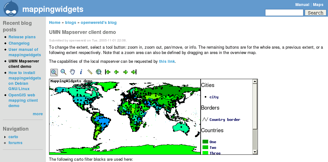
| All analysis is based on demo http://mappingwidgets.sourceforge.net/demo/mapserver | |
| Usability - General impression | no feedback on load time status during updating; panning only with Drag&Drop; limitless max/min zoom depth is irritating; noticeable: zoom history buttons |
|
Main map | simple; map size cannot be changed |
| Overview map | - |
| Layer overview | - |
| Legend | scroll bar, thematically grouped |
| Scale bar | - |
| Toolbar | usual functions (ZoomIn/Out, Pan, Queries, Distance function); noticeable: Zoom History buttons (first, previous, next, last) |
| Zoom bar | - |
| Pan navigation panel | - |
| General zooming | infinite max/min zoom depth; missing zoom depth orientation |
| Zooming with double-click | - |
| Zooming with mousewheel | - |
| Zooming with zoom box | yes (with ZoomIn tool; colorful underlay of pulled-out area) |
| General panning | unhindered smooth panning with Drag&Drop; no navigation arrows |
| Zooming/panning with keyboard | - |
| Tiling | - |
| 6. Other Features | |
| All analysis is based on demo http://mappingwidgets.sourceforge.net/demo/mapserver | |
| Analysis function | queries, distance function |
| Search function | - |
| Help function | - |
| Print function | - |
| 7. Notes | |
| module for CMS >>Drupal<< possible | |
| 8. Screenshot | |
| of analyzed demo | |
| |
![]() As of: May 15, 2007
As of: May 15, 2007
|
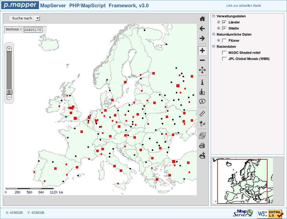
1. General | |
| Name | p.mapper |
| URL | |
| Home | http://www.pmapper.net |
| Documentation | http://www.pmapper.net/documentation.shtml |
| Download | http://www.pmapper.net/download.shtml |
| Live Demo | http://www.pmapper.net/demo.shtml |
| Current version | 3.0.1 (stable) |
| Last update | December 30, 2006 |
| License | GNU GPL |
| Developed by | Armin Burger |
| Short Description | P.mapper is a Free map server template system which is implemented with PhPMap Script, and offers an attractive user interface |
| 2. System | |
| Architecture | client-serverside |
| Programming language | PHP |
| Prerequisites | UMN MapServer and PHP/MapScript |
| Supported browser | Mozilla/Firefox 1.x+; IE 5/6; Opera 6.+: Netscape 6.1+ |
| Where applicable, integration with other software | based on UMN MapServer |
| 3. Community | |
| Revision Administration | SVN (http://www.pmapper.net/download.shtml) |
| Mailing Lists (URL) | https://lists.sourceforge.net/lists/listinfo/pmapper-users |
| Developer ML | |
| Mails per month1 | - |
| Total number of active developers2 | - |
| User ML | |
| Mails per month1 | 82 |
| Total number of active users2 | 61 |
| commercial support | u. a. Intevation GmbH, Osnabr�ck |
| 4. Documentation | |
| for installation/development/operation (suggestions, tutorials, URL) | Quick Install instruction and user manual; URL unter (1) |
| 5. Usability | |
| All analysis is based on demo http://www.pmapper.net/demo.shtml (medium) | |
| Usability - General Imperession | long load times, no AJAX supported panning; many functions; fast zoom action (subjective impression) through continuous zooming effect; demo only retrievable in pop-up window |
|
Main map | map size adjusts to browser window |
| Overview map | fixed zoom level, no centering required; section can be moved with Drag&Drop or mouse click |
| Layer overview | combined with legend; can be de/activated with check boxes; thematically grouped and collapsible |
| Legend | combined with layer display |
| Scale bar | Bar integrated into map; additional editable scale text field also available |
| Toolbar | comprehensive; noticeable: add location (set marker); download; select (multiple queries, note combobox menu under map, auto identify (=Infoabfrage) |
| Zoom bar | yes (remarkable: continuous zooming with slider, ie. on-the-fly scaling of map; enables good zoom depth orientation) |
| Pan navigation panel | - |
| General zooming | maximum zoom level '1:0' does not make sense; ZoomIn/Out tool remains active at max/min level; Zoom Reset; Zoom History (previous, next) |
| Zooming with double-click | - |
| Zooming with mousewheel | yes (as of v3.1) |
| Zooming with zoom box | yes (with ZoomIn tool; also by holding down Shift-key; colorful underlay of pulled-out area) |
| General panning | unhindered smooth panning with Drag&Drop; no navigation arrows |
| Zooming/panning with keyboard | yes |
| Tiling | - |
| 6. Other Features | |
| All analysis is based on demo http://www.pmapper.net/demo.shtml (medium) | |
| Analysis function | queries, distance measurements, add location |
| Search function | country and city search |
| Help function | - |
| Print function | HTML and PDF formats possible; with reference map, legend and scale |
| 7. Notes | |
| - | |
| 8. Screenshot | |
| of analyzed demo | |
| |
© June 1, 2007 |
Emanuel Schütze |
some rights reserved.
This work is licensed under the Creative Commons License
Attribution-ShareAlike 2.0 Germany.
| A.2 Free & client serverside | Contents |