Contents
| 6.2 Open Issues | Contents |
A basic problem in the use of tiling in web mapping applications is the WMS server's ability to automatically place a scale bar, pre-defined logo, watermark or signature on every requested map.
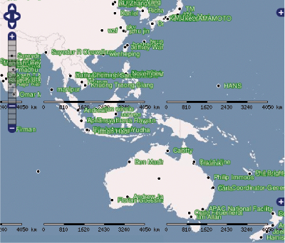
Figure 6.2 illustrates the potentially unaesthetic tile effects in OpenLayers using the examples of two WMS services. Maps that are supplemented with externally-generated and repetitive details divert the user's attention from the map content and therefore have a negative effect on Smart Map Browsing.
TileCache offers a technical approach to dealing with display issues such as these:
with the Metatile option the WMS server loads a large tile, which is subsequently provided to the web mapping application in the form of numerous smaller, subdivided tiles. By default a Metatile is divided into 5x5 tiles. Taking into account the recommended maximum tile size of 2048px by WMS servers, the complete display of large maps with only one meta tile would generally not be possible. Therefore this solution could still result in a recurrence of this undesired element.
A second tiling problem is the positioning of labels which extend beyond tile borders. In Figure 6.2 (left picture) these labels are simply cut off, which clearly impairs the readability of the map. A discussion of potential problem solving approaches would go beyond the confines of this thesis, therefore this issue is merely pointed out.
Furthermore two open issues are observed in the developed OpenLayers extension animated zooming:
© June 1, 2007 |
Emanuel Schütze |
some rights reserved.
This work is licensed under the Creative Commons License
Attribution-ShareAlike 2.0 Germany.
| 6.2 Open Issues | Contents |